Main Menu Labelling Interface Rules
Rule 7
Choose the fallow category if the fields looks like it was an annual cropland that is somewhat overgrown, and hasn’t been planted in a few seasons.
In practice it can be difficult to tell an actively used field that should be classified as annual cropland from one that is fallow. So what does “fallow” mean? According to the Oxford definition, it is:
(of farmland) ploughed and harrowed but left for a period without being sown in order to restore its fertility or to avoid surplus production.
In an image, you can recognize a fallow because it:
-
Has more vegetation growing in it then surrounding active fields, and;
-
This vegetation appears more variable in distribution, size, and shape throughout the field then you would expect in an active field.
You can see this in the image below, which shows growing and off-season false color images, as well as basemap imagery, over a complex landscape that has a mix of fallows and active fields. The fallows are indicated with blue arrows (and shown labelled at the bottom). Yellow arrows indicate areas that we consider to be non-agricultural (and therefore not labelled).
So how do we distinguish between i) fallows and active cropland, and between ii) fallows and non-agricultural land here? We give answers beneath the image.
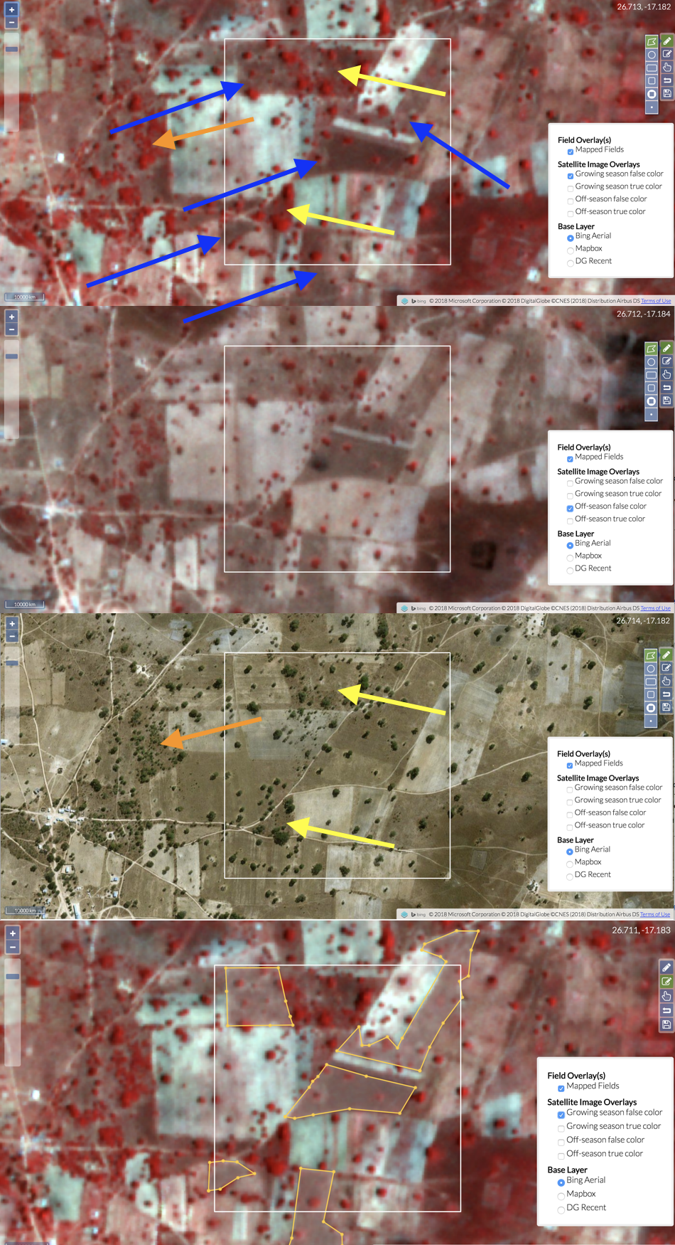
Answers:
-
To distingish between annual croplands and fallows, we see that active cropland tends to look more clear and brighter in this landscape, whereas the fallows appear somewhat darker, suggesting vegetative regrowth that occurs when the land isn’t ploughed.
This factor is evident in the fallow at the top of the target. The place we chose to label (blue arrow in top image and polygon in bottom) showed evidence of previous ploughing in the basemap. However, that ploughing was not as recent (because of the darker color) as the annual cropland right beneath it.
-
To distingish between fallows and land that isn’t farmed, we look at the degree of vegetation cover that is evident in both the Planet imagery and basemaps, as well as any suggestion of past ploughing.
There was no such evidence of previous ploughing in the area to the right of the topmost polygon shown by the yellow arrow. That area has a denser, woodier, and generally less cleared appearance than the fallow area we labelled, in both the Planet imagery (less obviously) and in the basemap (more obvious). That pattern of vegetation is similar to the pattern we see in the place indicated by the orange arrow. The pattern suggests that these areas are unfarmed, so we simply leave it unlabelled. The same goes for the yellow arrow-indicated area nearer the bottom of the labelling target.